The project team successfully upgraded the public from traffic information users to traffic information collectors
On October 9th, at 18:00, due to the unlimited number, the evening rush hour in Beijing was particularly congested that day.
But for Qi Peng, who commutes between Tongzhou and Zhongguancun every day, dealing with such congestion is "very good". Before setting out, he always uses the mapping software on his mobile phone to navigate, so that he can choose the best driving route.
"Mobile navigation is one of the most frequent apps I open every day. Whether I’m driving or taking public transportation, it allows me to reach my destination accurately and quickly," Qi Peng told reporters.
Nowadays, with the rapid development of cities in our country, the increase in car ownership, and the development of mobile Internet, there are more and more people like Qi Peng, and smart travel has become the "new normal" for many people.
So, how can these navigation software that acts as a "guide" provide accurate road conditions to avoid congested roads? How can navigation software provide reasonable travel plans to help us reach our destinations easily?
In this regard, the "Urban Traffic Guidance and Navigation Travel Key Technology and Application Service" project team composed of the Institute of Geographic Resources of the Chinese Academy of Sciences, Zhangcheng Technology, Qianfang Group and other units has spent many years of research, using satellite positioning, mobile communication, high-performance computing, geographic information system and other technologies to implement the real-time perception of the status of urban and intercity road traffic systems, accurately and comprehensively providing traffic conditions to the people through mobile phone navigation, roadside electronic bulletin boards, traffic radio and other channels. On this basis, the integrated driving behavior real-time sensing and analysis technology to achieve multi-mode and multi-standard dynamic navigation for public travel, improve travel efficiency; and assist traffic management departments to formulate traffic management plans, promote urban energy conservation and emission reduction, and improve urban operation efficiency. In the 2015 Beijing Science and Technology Awards review, the project won the first prize.
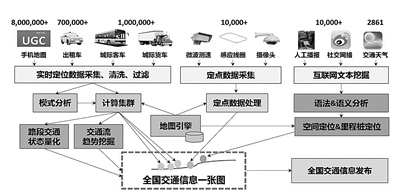
Create a national traffic information map
During the driving process, the navigation software would issue instructions and prompts in real time: "Turn left 100 meters ahead" "Congestion ahead is one kilometer, it is expected to take 5 minutes to pass"… Many people would be surprised, why is the navigation software so "smart"? Is it relying on the cameras on both sides of the road or the induction coil buried in the ground?
Lu Feng, the project owner and a researcher at the Institute of Geographic Resources of the Chinese Academy of Sciences, told reporters that traditional traffic information acquisition relies on devices such as induction coils deployed under road sections or video probes above roads. "These devices are fixed in location and have high costs, so they cannot fully reflect the real-time status of urban traffic."
Therefore, the project team must "find another way".
The project team "targeted" the taxis. Since the taxis were equipped with satellite navigation and positioning, they could periodically send back location and status information to the monitoring and dispatching center. These taxis that cruised the streets every day became an important source of urban traffic information collection.
However, taxis are not a "one-and-done" solution. After all, the scale and range of taxis are limited. Especially with the increasing popularity of self-driving travel, timely access to inter-city and even national traffic information has become a "rigid demand" for people to travel.
The project team decided to build a new "traffic status induction coil," which covers a wide range of areas, including long-distance buses and trucks, monitoring tracks, mobile phone map client side tracks, Internet websites and social network text messages.
"According to the requirements of the state, all long-distance buses, tourist chartered buses, dangerous goods transporters and general cargo trucks across the country must be equipped with mandatory traffic monitoring equipment to monitor the whole process of driving, prevent drivers from driving fatigue and reduce traffic accidents. These instruments will upload the driving track of the car in real time, and the accuracy rate is extremely high, so that we have a mobile information source covering the whole country," Lu Feng said.
Not only that, the project team also keenly observed that in the Internet age, a large number of users use mobile map services online every day, and these high-frequency satellite positioning trajectories have undoubtedly greatly expanded the ranks of car-based mobile information sources. In addition, there is a huge amount of traffic information on the Internet, both official and netizens’ own road conditions, road books and other information posted on social networks. So, can we make full use of these high-frequency trajectories of Internet maps and massive text on social networks to give full play to the power of the masses and obtain real-time traffic information?
In response to these technical bottlenecks, the project team broke through technical bottlenecks such as large-scale high and low frequency moving target trajectory map matching and traffic state analysis, Internet and social media text contains traffic information extraction, and multi-source traffic information real-time fusion, and built a service delivery and user feedback traffic information ecosystem. A nationwide traffic information service system was established, and a national traffic information map was realized.
The project team successfully upgraded the public from traffic information users to traffic information collectors. This information provides people with the operation status of the urban road network, effectively guides people to travel and avoid congested road sections.
"When you open the navigation software, your current traffic information will be automatically uploaded, which means that everyone is both a beneficiary and a provider of traffic information, which is also a manifestation of the Internet sharing economy," Lu Feng said.
It is reported that today, the system processes more than 2 million taxis and vans, more than 8 million mobile phone map tracks, more than 10,000 fixed sensors, and more than 10,000 traffic event texts every day.
The efficiency of navigation map update is greatly improved
In navigation, we often worry that map updates cannot keep up with changes in roads or surrounding business districts. Due to the intensive construction of cities and frequent changes in commercial outlets, current applications such as mobile maps generally have insufficient timeliness.
In the past, navigation map updates had to be done by collecting vehicles and other means. Unlike ordinary vehicles, there was a half-meter-high white shelf on the roof of the collecting vehicle, and the camera on the shelf could take a full-angle shot of the surrounding scenery, and then transmit it to the computer. Then, the data operator would post-process the captured video, generate or update the navigation map, and store it in the system.
"This kind of update is very labor-intensive, and often a navigation map company has to maintain a data collection and update team of several hundred people, and the cost is huge," Lu Feng said.
The project team believes that the mobile Internet has provided a good information sharing environment for businesses and the general public, and various time-sensitive road network maps and business service information have emerged in an endless stream. If these non-professional maps originated from volunteers are integrated with professional navigation map data, they can provide services to the general public faster and better.
In response to this technical bottleneck, the project team conducted in-depth research, first proposed a geometric pattern-based interest point and road network integration model, established a mapping relationship between the two, and broke through the problem of semantic consistency detection. Then, a heuristic probabilistic relaxation matching model was proposed to achieve the perfect integration of volunteer sources and commercial navigation road networks, with matching accuracy better than 95%, effectively ensuring the richness of information in travel navigation and map applications.
Convenient and accurate multimodal path navigation
Nowadays, the use of mobile phone navigation is not only in driving, but also in the bus, subway, bicycle or walking.
When we go to unfamiliar places by public transportation, we usually need to consider a series of questions: which bus to take? How to get to the bus stop? Which subway to change? How to change to the subway? Which subway exit to enter and exit from? How to get to where we want to go after getting out?…
Due to the differences in the road network environment, these personalized multi-mode travel needs are becoming increasingly prominent. Coupled with the real-time changes in road condition information and the rapid changes in the road network environment, how to provide multi-mode, multi-standard and reliable travel route choices according to the needs of the people?
In response to this problem, the project team developed a travel path planning algorithm group that takes into account different travel standards (short time, low cost, low fuel consumption, less transfer, etc.) and involves different travel modes (self-driving, taxi, bus, subway, walking, etc.).
The algorithm breaks through the technical bottlenecks of multi-mode traffic network spatial data model, multi-mode connectivity automatic processing, reliable travel time prediction, multi-mode multi-standard reliable path planning, multi-user concurrent path query load balancing, etc., and realizes the upgrade of the navigation system.
"We can provide a reasonable travel plan based on the starting and ending points set by the people themselves, and help the people reach the destination conveniently," Lu Feng said.
Environmentally friendly driver assistance systems reduce energy waste
Advocating green travel and achieving energy conservation and emission reduction is the eternal pursuit of urban transportation. Drivers’ bad driving habits often increase the fuel consumption cost of cars, resulting in energy waste and environmental pollution.
In response to this problem, the project team developed an environmentally friendly driving assistance system to provide drivers with a driving strategy suggestion function. This function uses mathematical modeling to transform environmentally friendly driving problems into optimization problems, and calculates the speed range of the car through traffic flow modeling. Then, the optimal driving strategy (optimal gear, speed) of the car in each speed range is solved through the equation between fuel consumption and the driving speed, gear position, and engine load of the car.
The system also collects vehicle driving data such as engine speed and acceleration through a variety of sensors to judge the driver’s environmental protection driving level, establish an incentive mechanism for environmental scoring rankings, and promote a benign change in drivers’ driving habits. At the same time, combined with real-time traffic information, a dynamic path method for energy-saving and environmentally friendly driving has been developed, providing people with green travel planning for energy conservation and emission reduction.
It is understood that the real-time traffic information released by the project covers major highways, national highways and provincial highways across the country (with a mileage of more than 85,000 kilometers), as well as 47 large and medium-sized cities such as Beijing, Shanghai, Guangzhou, and Shenzhen, with an accuracy rate of more than 90%. The research results are directly transformed into three software products and a traffic information service website, and through traffic information services and traffic information technology services, it has successfully cooperated with Internet manufacturers, automobile manufacturers, navigation map manufacturers, and mobile communication operators. The users of traffic information products exceed 200 million, and the daily visits exceed 10 million, generating direct economic benefits 120 million yuan.
The research results of this project have greatly improved the technical level of our country’s traffic information service industry, promoted the formation and improvement of our country’s traffic information service technology system, provided mature traffic guidance information support for large and medium-sized urban traffic management departments across the country, and provided hundreds of millions of users across the country with all-weather and large-scale smart travel information services. (reporter, statement)
关于作者